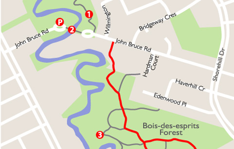
This 117 acre urban forest contains five different ecosystems – riverbottom, wetland, oak forest, aspen forest, and grassland and is considered a vital part of the 27 km Seine River Greenway, the ‘heart and lungs’ of the parkway system. It is the largest remaining riverbank forest in the city and is situated on the frontline of urban sprawl. What makes it so treasured is that it is still ‘virtually undisturbed.’
One special feature of the woods is a series of oxbows or abandoned riverbeds. These can be identified as U-shaped low lying areas along the trail. Oxbows were formed when a sharp bend or loop in the river eroded over time until the narrow neck of land between the two banks finally cut through creating a new straighter river channel. These abandoned river beds become highly productive riverbottom and wetland habitat supporting a rich variety of vegetation and wildlife.They are a favourite resting spot for the 20-30 whitetail deer that call the Bois home.
FAST FACTS
- gravel surface
- 2.0 km route length
- Parking
Parking circle on west side of John Bruce Bridge
Extra Foods parking lot at St Anne’s Rd and Southglen Blvd
POINTS OF INTEREST
- Louis Riel Sr Route
- John Bruce Bridge
- Woody
- Great Grey Owl carving
- Royalwood Bridge

